|
Trails to the Past of Utah is requesting any genealogy materials that you may have such as Obituaries, News Clippings, Wills, Deaths, Births, and Marriages, You do not need the certificates, but only the source of the information. If you should happen to have any of these items, please email them to Marie Miller, the State of Utah Administrator. Thank you.
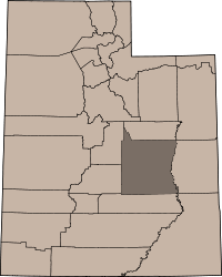
Its county seat is Castle Dale, and the largest city is Huntington. The county was named for George W. Emery, governor of the Utah Territory in 1875.
Occupation of the San Rafael region dates back thousands of years to include people of the Desert Archaic Culture who were followed by those of the Fremont culture who inhabited present day Emery County from about A.D. 500 to about A.D. 1300. Evidence of these people can still be found in numerous pictograph and petroglyph panels, such as those in Temple Mountain Wash, Muddy Creek, Ferron Box, Black Dragon Canyon, and Buckhorn Wash all sites listed in the National Register of Historic Places. Ute Indians also occupied sites in Castle Valley.
The old spanish Trail The first white men who came to Castle Valley were undoubtedly Spanish Traders and Explorers. These explorers came to the area sometime after Silvestre Vélez de Escalante, who in 1776, crossed northern Utah through the Uintah Basin. These Spanish traders and explorers eventually found a more southerly route than Escalante had traveled, which became known as the Spanish Trail. It began at Santa Fe, thence to Durango, Colorado, crossed the Colorado River where Moab is now located, then to the Green River-crossing where Green River is now located, thence westerly to Cedar Mountain. It went on the South side of Cedar Mountain, across Buckhorn Flat, passed the Red Seeps to Huntington Creek, crossing about a mile below where the present bridge crosses; thence to Cottonwood Creek. It crossed the Ferron Creek where Molen now stands. It passed through the Rochester Flats about one mile (1.6 km) east of present day Moore and crossed the Muddy Creek about two miles (3 km) due east of the present town of Emery. It then went over Salina (Salt Creek) Canyon. It then turned south and went through Parowan, Mountain Meadows, Las Vegas, Barstow California and to the coast. They had to enter Castle Valley in order to avoid the straight walled canyons of the San Juan, Colorado, Green, Dirty Devil, and San Rafael Rivers. Eventually, after many years of exploring, the best route became the Spanish Trail. The principal trade which developed between Santa Fe and the Utah region was slavery. The trading of Indian women and children to the Spanish, although illegal, was the purpose of the Spanish coming into the area which was to become Utah. The other use of the trail was to herd livestock, mostly horses, from California to Santa Fe. Since the slave trade was illegal, the traders kept neither records of their activities nor the extent of their travels and explorations. Travelers along the Old Spanish Trail gave Castle Valley its names, as the travelers marveled at the "castle" geologic formations throughout present day Emery County.
The first Americans to come to Castle Valley were fur trappers. The very first were the "Lost Trappers", James Workman and William Spencer, who had been separated from their trapping party by Comanche Indians and had wandered all the way to the Moab crossing of the Colorado River hoping that they would find Santa Fe. Here they met a Spanish caravan of forty or fifty people going to California. They joined the caravan and traveled through Castle Valley in 1809 and went on to California. In 1830, William Wilfskill came to Castle Valley along the Spanish Trail. He and his party were fur trappers but found little in the area to keep them here.
Following the trappers in the late to 1840's and early 1850's, government explorers came to the valley to find routes across the continent. Kit Carson was the first of these famous men. He was looking for a direct route for the mail to be carried overland from St. Louis to California. Carson carried through Castle Valley to the nation the news of gold being found in the Sierra Nevada in 1848.
In 1853 John W. Gunnison, an Army Topographical Engineer came through Castle Valley for a route for the Pacific Railroad. He was commissioned for this assignment by Jefferson Davis Secretary of War. He left very detailed descriptions of his travels and carefully laid out his route through Castle Valley. Gunnison's route first met the Spanish Trail at the Green River crossing. He followed this trail for a short distance west of the Green River, but when the Spanish Trail entered the rugged rocky region that we today call the Sinbad Reef and charted a route around this feature.
The third government explorer was John C. Fremont. He came through the valley in the winter of 1853-54. The trip by Fremont to explore the west is noted because of the many difficulties that he had resulting from the winter weather. They suffered greatly from lack of food and from the inhospitable landscape. There was no relief from their difficulties until they left Castle Valley and made their way to the small Mormon settlement of Parowan.
In 1875 livestock growers from Sanpete County brought cattle and sheep into Castle Valley to graze, and several recognized the settlement potential of the region. With a shortage of sufficient land and water in Sanpete County and a strong desire by LDS Church leaders to acquire unoccupied land in the region before non-Mormons did, young families began moving into Castle Valley in the fall of 1877 to take up homesteads in what would become the settlements of Huntington, Ferron, Castle Dale, and Orangeville.[
In late August 1877, Brigham Young, president of The Church of Jesus Christ of Latter-day Saints (LDS Church), issued an order to the Sanpete LDS Stake president seeking "at least fifty families to locate in Castle Valley this fall." The order led to the founding last Mormon colony settled under the direction of Brigham Young. One week later on August 29, Young, the Great Colonizer, died. During his 30 years as leader of the LDS Church, Young had overseen and directed the establishment of almost 400 towns and villages. The settlement of Emery County was his last.
Soon after issuance of Young's order, several bands of settlers moved out from the Sanpete region headed for Castle Valley (Emery County). They settled along Huntington Creek, Cottonwood Creek, and Ferron Creek. The following spring (1878) several more families moved into the region. In the spring of 1878, Elias Cox and Charles Hollingshead set up a sawmill in Huntington Canyon to provide lumber for the colony. On Ferron Creek, setters plowed lands and began construction of a ditch for irrigation. Most of the early settlers in Castle Valley claimed easily watered bottom lands along the creeks and rivers, and by 1879, most of the best lands had been taken up.
Emery County was created by the Utah Territorial Legislature in February 1880 and included what later became Carbon County, Utah. The census of 1880 showed 556 people and 84 farms in Emery County, but this figure is likely short as many prominent settlers were inadvertently left off the county rolls. By 1890, the population of Emery County had risen to 2,866, and towns had grown from groups of ramshackle cabins to communities with schools, stores, and churches. Between 1880 and 1900, many significant canals were constructed, including the Huntington Canal (1884), Emery Canal (1885), Cleveland Canal (1885), and the Wakefield Ditch (1880). Many of the early canals are still in service.
In the early 1880s, the Denver and Rio Grande Western Railroad began investigating rail routes through the Emery County region. Early plans to locate the railroad through the heart of Emery County were thwarted when the route over the Wasatch Mountains proved to be too steep. The alternative route took the rails through the north-eastern corner of the county, by-passing most of the settlements in the county. While most of the county did not immediately benefit from the railroad, Green River, on the eastern edge of Emery County boomed almost overnight following arrival of the rails.
Cities and Towns
Castle Dale
Clawson
Cleveland
Elmo
Emery
Ferron
Green River
Huntington
Lawrence
Mohrland (ghost town)
Moore
Orangeville
Woodside (ghost town) |
|
Adjacent Counties
Carbon County, Utah (north)
Grand County, Utah (east)
Wayne County, Utah (south)
Sevier County, Utah (southwest)
Sanpete County, Utah (northwest)
The information on Trails to
the Past © Copyright may be used in personal family history research, with source citation. The pages in entirety may not be duplicated for publication in any fashion without the permission of the owner. Commercial use of any material on this site is not permitted. Please respect the wishes of those who have contributed their time and efforts to make this free site possible.~Thank you!
|